


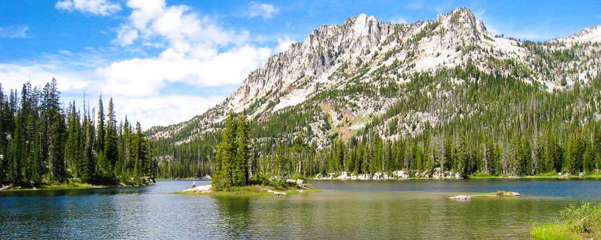


In an alignment of perfect circumstance - climate, geology, and eons of time - converged to create the great moraines that form Wallowa Lake, a truly special place that awes everyone who first lays eyes upon it. Located at the edge of Oregon's largest wilderness- 361,446 acres of unspoiled alpine lakes populated with mountain goats, big horn sheep, black bears, wolves and even wolverines- Wallowa Lake has inspired passionate expression in words that for many ultimately fall short.
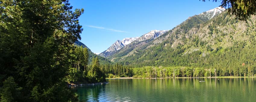
When you drive into the Wallowa Valley for the first time, the scene is a breathtaking experience in and of itself, but it’s at the end of the road where the real treasure is found. This glacially formed lake, with its crystal-clear, deep blue water and majestic mountain backdrop, creates the illusion of having stumbled into Switzerland, earning the Wallowas the nickname “Oregon's Alps” and a place among Travel Oregon's 7 Wonders.
Take the Grand Tour: View 27 Spherical 360 degree Panoramas of the surrounding area.
Family Favorite

There's something for everyone at Wallowa Lake, with many activities that appeal to young and old alike. Take a spectacular tram ride and spend an exhilarating day strolling at the top of the world. Play mini golf, ride a horse or race go-carts; the opportunities for quality together-time abound. For many families, visiting the lake is a tradition, and for the lake, entertaining families is too!
The south end of the lake was developed around 1906 with an amusement park that consisted of a store, lunchroom, 2-lane bowling alley, dance pavilion, horse corals and a lodge. During those early days, a ferry took people to the other side because there was no road. While many attractions have come and gone over the past century, the atmosphere at Wallowa Lake remains much the same, with family-owned businesses offering hospitality reminiscent of a simpler time.
Features and Facilities
Wallowa Lake State Park

At the south end you'll find one of Oregon’s most popular state parks, which includes a marina, a swim beach, and several day use facilities allong the Wallowa River and Wallowa Lake.
Riverside Day Use Area > View Gallery

The parks main day-use area is a beautiful 60 acre fee-free area that’s just east of the campground and is open to all visitors. Bordered on the east side by the river and the north by the lake, this area has plenty of tables as well as a covered group pavilion that can be reserved. It also has an expansive open area for playing Frisbee or other ball games, and a disc-golf course in the trees. There are plenty of other features for nature watchers, fishers, swimmers and sunbathers. The ancient forested grounds have some paved trails with bridges that wind through beautiful mowed grounds.
Little Alps Day Use Area > View Gallery

About a mile up the road, almost to the trailhead, you'll find another day-use area. This forested spot is complete with picnic tables, a restroom and dirt trails that are stable enough for wheelchair access, as well as several interesting paths to a secret viewpoint above the valley!
Wallowa Lake County Park > View Gallery

On the north end of the lake you’ll find the county day-use area. While not nearly as expansive, it’s equipped with a great double boat ramp, tie-up dock and several picnic spots. The beach is ample and has a protected swimming area for the kids. This sunny location, due to the prevailing breeze, is typically warmer for swimmers too. It’s also where the fireworks are launched just offshore for Independence Day. Lying on your back while the shells explode overhead, completely filling your field of view while listening to the echoes boom through the mountains, redefines the whole experience.
Wallowa Lake Trailhead > See the Hiking Page for more.

This is the gateway to the incredible Eagle-Cap Wilderness, Oregon's largest. From here you can park for free and obtain a free permit to stay, camp and hike in the wilderness. The primary trail is the West Fork Trail, which leads to Ice Lake, 6-Mile Meadow and the popular Lakes Basin area. The East Fork Trail leads to Aneroid and Bonny Lakes and beyond. The Chief Joseph Trail leads up to Chief Joseph Mountain and some of the best views overlooking the lake.
Iwetemlaykin State Heritage Site > View Gallery

This 62 acre site, adjoining Old Chief Joseph's burial ground, was finally protected in 2009 through the great efforts of The Nez Perce Tribe, the Confederated Tribes of the Colville Reservation, the Confederated Tribes of the Umatilla Indian Reservation and area locals. The trails are fairly gradual and graveled for casual hiking or running. A small pond, running stream and meadows are some of the features of this beautiful park, making it a great place for a short day hike.
The East Moraine > View Moraine Hiking Page

If you like singing through mountain meadows, while being wowed by incredible vistas, then the Wallowa Lake East Moraine is sure to fit the bill. The original inhabitants, the Nez Perce, considered it sacred ground - It’s easy to see why. The Moraine is accessed from three points, each gaining up to 800 feet to reach the top making this a moderately strenuous hike, but so worth it!
Low Light Pollution means stars, Stars, STARS
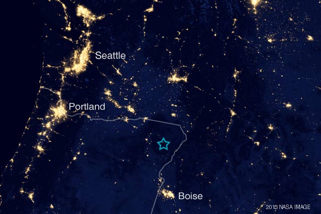 Wallowa Lake's night sky is very dark
 A new moon rises in the eastern sky in early May over Wallowa Lake. Astrophotography by Jeff Baird
With such a low population density and long distance to cities, Wallowa Lake sits in one of those ever-shrinking dark spots on the Earth. That, and the clear mountain air combine to make stargazing a delight, especially to those from metropolitan areas who never realize that the sky is filled with so many stars and who rarely get to enjoy the Milky Way. Bring or load your star map or planisphere and spend some time learning the constellations while you catch the streaks of shooting stars. The Perseids meteor shower in mid-August is especially impressive.
Clean, Clear Water

Despite having a wild mountain river feeding it with organic material and sediment, Wallowa Lake is remarkably clear and clean. On a calm day its easy to peer down and watch fish swimming along the bottom, allowing quiet fisherman to do a little 'see fishing.' Until 1994, the neighboring town of Joseph drew all its water from the lake without ill effect- it's that clean. So, if you're out swimming or skiing and you accidentally get a mouthful- have no fear, you'll probably be just fine.
Geology

Wallowa Lake is the largest of several glacial cirque lakes in the area. It was formed by repeated periods of glaciation that began some 3 million years ago and ended about 15,000 BC. The glaciers formed high in the Wallowa Mountains around Glacier Lake and moved down the East and West Fork of the Wallowa River. As these glaciers advanced and retreated they carved out the river valleys and carried down rocks and sediment forming the twin and terminal moraines which rise over the lake some 900’. Along the moraine ridges, large granite boulders called ‘erratics’ were left behind, a few as big as cars. The glaciers also deposited boulders across the area around Joseph which was named 'Hah-um-sah-pah', by the Nimiipu (Nez Perce), meaning 'big rocks lying scattered around.’
Geologically, the Wallowa Lake Moraines are considered a near perfect example, and finally recieved protection and access to the public. Visit here for hiking information.
Size and Elevation
The lake is about 3.7 miles long and about 3/4 mile wide with a depth of 299 feet, which, for a lake of such size is very deep. In 1917 a local non-profit group of farmers built a dam that raised the lake level by about 28’. The dam has seen better days and is now under consideration for reconstruction using federal funds that would include fish passage, along with plans for bringing the migratory run of sockeye back that was extinguished with the dam’s original construction.
At an elevation of 4,372 ft, Wallowa Lake sometimes freezes solid in the winter and until it has had several weeks of warm weather it remains on the chilly side. The water warms enough for skiers and swimmers typically by early to mid-July although many still use a wetsuit.
Location
Wallowa Lake is located about one mile south of Joseph, Oregon, (pop. 1,081) and seven miles south of the largest town in the county, Enterprise (pop. 1,940). The closest major town is La Grande, Oregon (pop. 13,102) about 1 ½ hour away. Driving distance from Boise, Idaho is about 4 ½ hours and from Portland, about 6 hours. This end-of-the-road, distant locale prevents the normal big-city onslaught that plagues most tourist destinations. You’ll find traffic to be relatively light on all but the busiest weekends.
Seasons & Weather
Spring

Spring can be a real mix of weather. It typically starts with a feign of warm, dry weather in March or May that makes you think that summer is here. After several weeks of this we are usually treated to a few spring snows followed by a mini-monsoon spell that thoroughly soaks everything. This can last well into June but in its aftermath the most wonderful thing occurs: plants BOOM! The grass turns the most unreal electric-green and the hills take on color as well. Wildflowers bloom everywhere turning uncultivated fields into nature’s flower gardens. With the snow still thick on the mountains and the air crisp and cleaned, this is the most visually striking time to be here. It’s also the best time to fish for Kokanee.
Summer

Summer daytime temperatures are typically warm to hot (80-95 F) and dry. At night temperatures usually fall quickly; sleeping in a hot uncomfortable bed is rare. These relatively comfortable temperatures are what drove the Nez Perce and today’s visitors to this area. ‘Going to the mountains’ is as much about escaping the awful heat of the lowlands as it is about seeing the mountains themselves. The third week in July is usually the hottest and by then the water has warmed up enough to take the edge off. During mid-July to late-August the temperature can reach the upper 90’s and if you’re swimming on the north or south beaches when the breeze is blowing towards them the water can get quite nice, even warm. Keep that in mind if your kids want to go swimming, but hate the cold.
Weather is generally unpredictable in all mountain areas and even though early July daytime temperatures are usually in the lower 80’s, there have been several occasions where it’s snowed on Independence Day. So, don’t forget to pack a jacket, even in summer.
If you’re lucky, you may be treated to a thunderstorm. They’re quite different from other regions in that the mountains channel the sound and energy in spectacular ways. They’re not uncommon in the summer where the Wallowas make their own weather, especially when the airflow is from the south. They build up in the afternoon and can quickly change the conditions on the lake to one of churning, stormy seas- so it’s something to keep an eye on if you’re in a small boat. Chief Joseph’s original name was Hin-mah-too-yah-lat-kekt, meaning ‘Thunder Rolling Down the Mountain.’ Until you witness the lightshow and thunder that echoes through these mountains, you’ll never truly appreciate the tremendous power in that name.
Fall

Fall is almost always the ‘Indian Summer’ variety. As the days shorten and the first frosts occur, the cottonwoods, alders and aspens change into their most wonderful colors. School starts and the number of visitors drops to a trickle. Warm fall weather can draw itself out clear to Halloween, with many days in the low 80’s making this usually-dry season a strong favorite of locals and visitors alike. Fall is also when the Swiss-Bavarian celebration of Alpenfest occurs, taking place in downtown Joseph, just as the red maples begin to blaze.
Winter
 A view of the Seven Devils from the top of the East Moraine in January
The winters are long and fairly cold with temperatures in January ranging about 10 to 25 degrees during the day and dropping another 20 degrees at night. There are many brisk, sunny days with low humidity that are very enjoyable, especially if you’re engaged in some kind of exercise like skiing or snowshoeing. The Salt Creek Summit Sno-Park is a mecca for snowmobilers, skiers and snowshoers and is just a 45 minute drive, making lake lodging a good spot for your home base. If you enjoy downhill skiing and snowboarding, Fergi, the local ski area, is only about a half-hour away.
Wildlife
Birds > View our Local Birding Guide

Bird life including eagles, osprey, geese, mergansers, various ducks, and the occasional swan or loon can be seen. There is a nesting pair of American Eagles that usually maintain a nest in an old cottonwood snag right on the south shore, for all to see. See our Bird Guide.
Mammals > View our Guide to Local Mammals

To the delight of visitors, Wallowa Lake has a sizable herd of mule deer that are very comfortable with their human pets. They’re one of the first things people notice as they drive in, strolling down the highway, lounging in people’s campsites and generally sniffing around for a handout. Too much human food has resulted in much of the herd suffering diarrhea and illness, which is why feeding them is prohibited. Ignore the temptation; you'll still get to enjoy their presence while they browse the many treats nature provides.
The area is also home to elk, bighorn sheep and mountain goats at higher elevations. Smaller mammals include various kinds of squirrels, skunk, martins, mink, fox and river otters. Coyotes, cougar, wolves and black bear are quite common, though not usually seen. See our Wildlife Guide.
Explore!

This is a vast and diverse area with environments that range from alpine to semi-arid desert. There are flat valleys, rugged canyons, razor sharp ridges and mountains over 10,000 feet. There are endless miles of dirt road (bring your maps and GPS) and approximately 500 miles of developed trails, just in the Eagle Cap! Go for a stroll and end up in blissful solitude surrounded in wilderness. Take an exhilarating drive to one of the lookouts. Spend an incredible day in ‘big sky’ country in the pristine grasslands of Zumwalt Prairie.